Getting back to nature with camping trips to Đồng Nai
Đồng Nai Province has recently become a new destination for people who love camping and exploring the beauty
GIA LAI – Reader Ta Thi Hoa shares a detailed journey to conquer Chu Nam peak, where peaceful nature has a little imprint on humans.
I grew up in Pleiku but now I live in another city. Information about the hiking attractions of my hometown always attracts and motivates me to experience them when I have the opportunity. In particular, I am interested in Chu Dang Ya and Chu Nam – two popular mountains in the last 5 years with the experience of watching the wildflower season at the end of the year or camping on the top of the mountain waiting to watch the sunrise.
Having experienced multi-day camping trips, I find such trips need to be organized in groups with clear preparation and assignment of tasks. Personally, I like day trips, with a travel distance of about 5 to 20 km to take the initiative in time, compact luggage and meet the needs of training and relaxation.
Even if it’s a day hike, I always find out in advance the basic information about the starting point, direction, distance, ability to complete the goal… But when I want to walk to the top of Chu Nam, I receive it. The information shared by previous friends is quite general like “you can climb from anywhere”, “just go ahead”, “if you see the nearest parking place, send it”… Or suggest going from the direction of the dam. Tan Son up, but did not guide the specific starting point.
Sharing accurate information about each trip will be of value to many people – especially in sparsely populated and poorly-informed locations like Chu Nam. I hope the trekking journey to Chu Nam peak below will be somewhat useful for those of you who are passionate about exploring and planning to conquer this mountain.
Starting point from Ia Gri . village
At the foot of Chu Nam mountain is Ia Gri village (Chu Dang Ya commune, Chu Pah district) of the Jrai people. According to the portal of Gia Lai province, the village has 93 households. I was glad to see that the concrete road had reached all the way to the houses in the depths near the foot of the mountain.
I rode my motorbike into the yard of a house in the middle of a coffee garden at the end of the concrete road leading to the village. The host, a young Jrai woman, opened the door, nodding in agreement when I asked for permission to park the car to go hiking. Thinking that the owner might go away or go to the field after that, I immediately sent 20,000 VND to thank him for sending the car.
I pointed to the slopes of Chu Nam, close to Chu Dang Ya, and asked if I could go to the mountain this way. The owner replied: “I can go but it’s very steep, I’m afraid I can’t go, I go to the other side”. She pointed in the direction of a red-tiled concrete gate in the middle of the coffee garden with the cassava and dragon fruit fields. This is the entrance to the village cemetery, there are only a few graves at a preliminary count, no sign of the traditional Jrai tomb house anymore.
From the cemetery, I headed to the eucalyptus trees at the foot of the mountain at the instruction of a young Jrai mother who took her two children to visit the grave at the end of the year. The oldest son, about 8-9 years old, asked: “Are you alone?”, his voice was so cute. When I asked him to come along, he smiled a little confused.
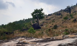
The way up is beautiful but harsh
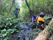
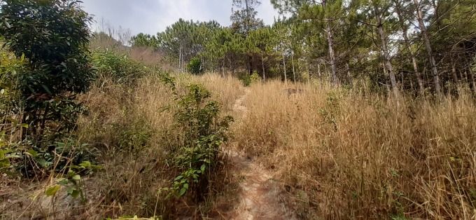
In turn, I sank into the layer of foxtail grass, eucalyptus, three-leaf pine forest, and the “rock garden” layer from low to high. The forest layers are connected by a trail of more than 3 km with the footprints of the Jrai people and of the mountaineers.
In the pine forest, there is the sound of birds singing, the sound of streams flowing from afar and near, sometimes the sound of geckos makes me stop to listen. About a quarter of the way through, I came across a puddle of water around the bamboo fence. Water gushed out from the veins. From the puddle, there is a rudimentary pipe leading down the mountain. Having heard about the Jrai people’s Water Drop worshiping ceremony, I thought this was the water source of Ia Gri village, so I didn’t violate it.
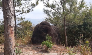
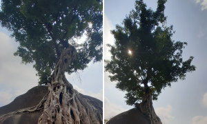
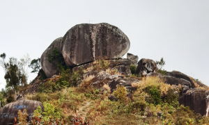
From the pine forest to the “rock garden” layer, the road is steep. I struggled to climb even though my backpack was light with only a few bottles of water and basic medical supplies, a hat, and a shirt. The gate to the garden is a rock shaped like a gorilla. In the cool air halfway up the mountain, visitors can see bonsai, stone statues created by nature and rain and sun.
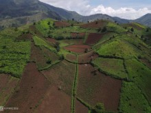
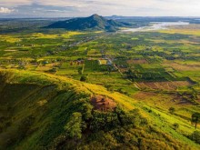
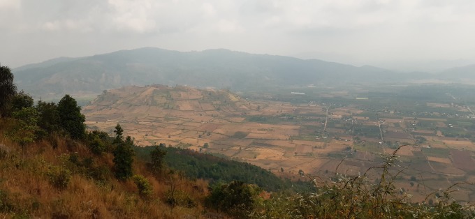
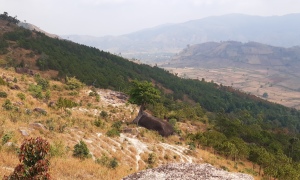
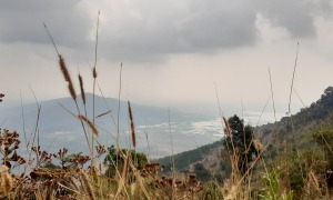
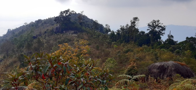
Sitting on a rock, looking around, you will see the shape of Chu Dang Ya mountain, catch the smell of young rice of Chu Jór field, see the sparkling northern part of Tonle Sap.
Chu Nam Peak is still ahead, I have to try to escape the fascination of the rock garden and keep going. In the last quarter of the way, due to erosion, only trees and shrubs remain. The road is very steep and there are slippery sections. Those who are not confident with the height should consider going with a professional organizing company.
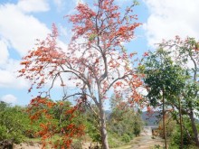
Chu Nam Peak to me is a garden full of pure and cool plants and flowers. Someone sympathetic wrote the words “heavenly garden” in chalk on a rock. Walking through the garden, I think Chu Nam is a place where all souls can reach. And Chu Nam touched my soul deeply.
Thanks to the kind Jrai relatives and good health due to regular cardio, I finished walking up Chu Nam and down in 4 hours. Starting from the parking lot at 10:00, it took me 1 hour and 50 minutes to get to the place where the cross was on the rock. The workout gear I carry has GPS to assist with measuring distance and time. According to this device, the position I started going was at an altitude of 805 m and stopped at an altitude of 1,383 m above sea level. Perhaps walking a little further can get a higher score, because the altitude of Chu Nam according to Google Maps is about 1,400 m.
Going down was less effort, but I lost track of the trail so it took 600m to go around. Going down is easy to go wrong because sometimes the trail is winding and the landmarks below are hidden. However, the downtime is the same as the upturn.
In the last days of January, Gia Lai’s temperature is quite high, 31 degrees Celsius. I have to wait for days with lower temperatures, 28-29 degrees Celsius to go for less sunshine. Fortunately, the day was cloudy, so when I went down the mountain around noon, it was not hot or sunny.
If you plan to conquer Chu Nam, you can start earlier, around 8 am to be able to finish in the morning. Also, as pointed out above you try to remember the road signs so that when you turn down you don’t go around.
Finally, wear long-sleeved clothing with good stretch for ease of movement and to avoid scratching because tall grasses have thorns. If possible, you should bring climbing shoes to protect your ankles and prevent slipping.
Follow (vnexpress)